
We’re making progress!
Implemented Projects
- Resolution to prepare a zoning map from July 13, 2021
- Feasibility study on new road connection
- Urban development concept
- Mapping with a view to species protection
- Funding from the 2023 urban development program of the State of Baden-Württemberg – first tranche in the amount of EUR 3.2M
- Creating a framework plan
- Expert opinion on profitability
Ongoing processes
- Assessing the construction of a new streetcar connection and a suburban train stop
- Creating a climate and energy concept based on the municipal heating plan
- Assessing site acquisitions
- Carrying out preparatory investigations
Planned processes
- Design and location approval process new cross-town artery
- Implementing the due process for creating a zoning map
Planning Objectives and Core Activities
The Zweckverband Interkommunales Gewerbe- und Industriegebiet Heidelberg-Leimen (Special-Purpose District Inter-Municipal Commercial and Industrial Area Heidelberg-Leimen) was founded by the two cities Heidelberg and Leimen on January 1, 2021.
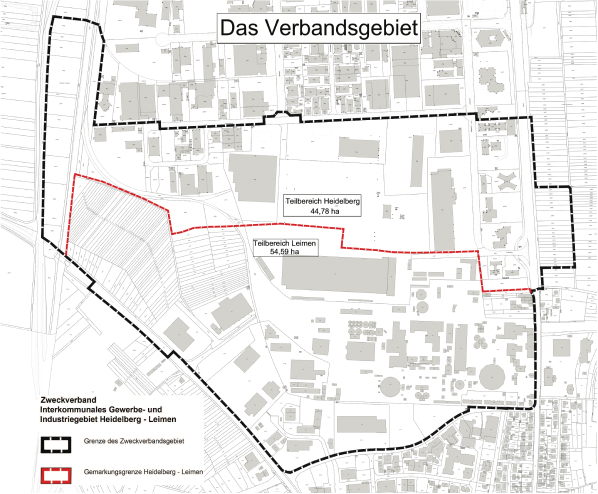
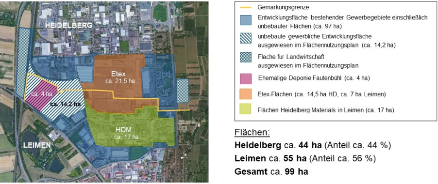
Planning, developing and conceiving a joint commercial and industrial area by taking into account plots of land, plots of land that are to be zoned and plots of land that are not zoned on both municipality lands as well as areas of the two large plants Etex (formerly Eternit GmbH) and Heidelberg Materials (formerly HeidelbergCement AG) that will free up. In particular, settlement structure, use and development are to be reorganized – where required, based on urban planning. Special emphasis lies on taking into account environmental issues as well as the interests of local businesses.
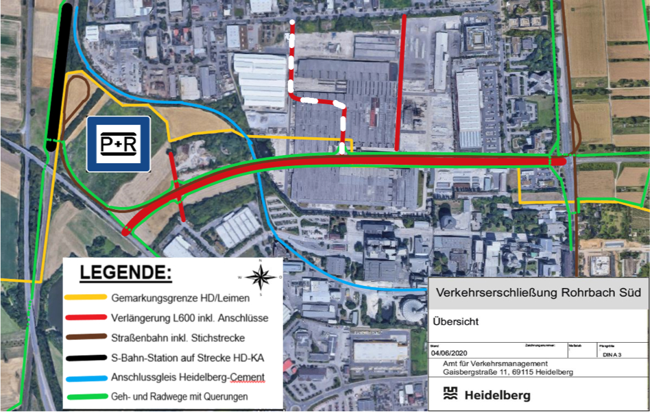
Feasibility Study on Infrastructure Development
One of the main activities of the Special-Purpose District is optimizing transport infrastructure by building a new connecting road, which includes constructing a bikeway network, a new streetcar connection and studying the idea of building a suburban train stop on the Special-Purpose District’s territory. A first feasibility study by engineers Koehler & Leutwein from 2019 describes the construction of a connecting road “straight through the Eternit premises” from the federal state road L 594 on Heidelberg’s municipality land to the L 600 on Leimen’s municipality land as a significant relief for traffic congestion and as positive for the development of the inner areas of the Special-Purpose District’s territory. Further studies of Koehler & Leutwein have confirmed existing results. They have been summarized in a preliminary study from March 2020 as well as in an explanatory report from October 2021.
The Road to a Joint New Zoning Map
When the Special-Purpose District was founded, first planning objectives regarding the reorganization of existing urban development plans and regarding transport infrastructure were set down in a concept. Together with LBBW Immobilien Kommunalentwicklung GmbH (KE), we developed an urban development concept, which was approved by the Special-Purpose District Assembly in July 2022.
The inventory regarding environmental protection rules for the Special-Purpose District’s territory was completed in 2022. The Special-Purpose District puts special emphasis on climate protection. Based on the municipal heating plan, we will commission a separate expert opinion on climate protection and energy supply for the Special-Purpose District’s territory.
In May 2023, part of the Special-Purpose District’s territory was awarded funding from the urban development program of the State of Baden-Württemberg, amounting to EUR 3.2M. KE was charged with the preparatory investigations required for determining a neighborhood improvement area, which is set to be completed by spring 2024. July 2023 saw the first step towards creating a framework plan with the start of a cooperative planning process. Renowned planning agencies drafted urban development concepts for the Special-Purpose District’s territory, with a special focus on taking into account the transport infrastructure. In a second step, these urban development concepts will go into greater detail. The framework plan will be based on the results and objectives of the neighborhood improvement plan as well as the preparatory investigations.
Preparatory Zoning Map
With the foundation of the Zweckverband Interkommunales Gewerbe- und Industriegebiet Heidelberg-Leimen (Special-Purpose District Inter-Municipal Commercial and Industrial Area Heidelberg-Leimen) on January 1, 2021, the two cities Heidelberg and Leimen have conferred their planning jurisdiction for the Special-Purpose District’s territory to the Special-Purpose District.
The Special-Purpose District Assembly resolved to create a zoning map for the entire Special-Purpose District’s territory on July 13, 2021. Within the framework of preparing a zoning map applicable to the Special-Purpose District’s territory, the existing zoning maps of the Cities of Heidelberg and Leimen will be replaced and planning laws will be established for areas that are so far undeveloped. Future urban developments will be based on a consistent and coordinated planning concept. At the same time, the zoning map creates the basis for joint planning and developments set to optimize transport infrastructure. Where necessary, developments will be based on partial zoning maps to be able to react more quickly. The publication of the resolution to prepare a zoning map can be found here:
Publication of the Resolution to Prepare a Zoning Map
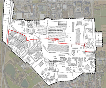
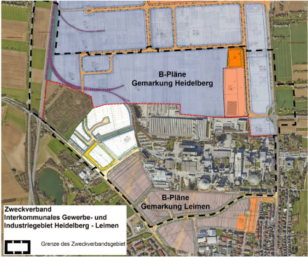
Territory of the preparatory zoning map
Existing Zoning Maps
Decisions on incoming building permit applications are made based on currently applicable zoning maps, insofar as they do not oppose the planning objectives of the Special-Purpose District.
An overview plan shows the areas where currently applicable zoning maps have been replaced.
Overview applicable zoning maps
There are three zoning maps that apply to Heidelberg municipality land:
Zoning Map Rohrbach: Commercial Area Rohrbach-Süd, amendments 6, 7 and 8
Zoning Map Rohrbach: Commercial Area Rohrbach-Süd „Health Center – Im Breitspiel“
There are five zoning maps that apply to Leimen municipality land:
Commercial Area North II, 1st amendment and new version
Commercial Area North III, 1st Section
Commercial Area North III, 2nd Section, Part 1
Commercial Area North III, 2nd Section, Part 1, 1st amendment
The administrative unit of the Special-Purpose District recommends consulting the relevant bodies before submitting a construction application. Please get in touch for further information.
Right of First Refusal
The statutes concerning a special right of first refusal according to § 25 of the Baugesetzbuch (German Building Code) apply for the plots of land located between the train line Heidelberg-Bruchsal and the federal state road (Landesstraße 594) on the Special-Purpose District’s territory. The right of first refusal concerning properties and plots of land is a legal instrument that supports and ensures an orderly urban development in accordance with the urban development plan.
The statutes and the plan on the right of first refusal concerning Heidelberg municipality land are accessible here.
The statutes and the plan on the right of first refusal concerning Leimen municipality land are accessible here.
Renovations as Part of Urban Planning
In late 2022, the Special-Purpose District has submitted an application to the Ministerium für Landesentwicklung und Bauen Baden-Württemberg (Ministry of State Development and Building Baden-Württemberg) to be admitted to an urban planning program for renovations. One essential basis for this application was the urban planning development concept approved by the Special-Purpose District’s Assembly on July 19, 2022.
Development concept final report
Based on the decision from May 5, 2023, the Special-Purpose District was accepted to the Government and Federal States Program “Urban Development Support” and received an initial funding of EUR 3.2M. This measure will run until April 30, 2032.
With the funds from the urban planning and renovation program, we will prepare and implement renovations in some parts of the Special-Purpose District’s area.
Before determining a neighborhood improvement area, we will need to carry out preparatory investigations (site assessment). These will be the basis for all assessment documents concerning the necessity of renovations, a survey of the built-up area and the structural situation as well as respective implications, the general objectives and the general feasibility of renovations. Apart from this analysis, the report to be created on the preparatory investigations will contain information on any urban planning issues and respective recommendations for corrective measures, a suggestion on demarcations and a cost and financial overview for roll-forward. These preparatory investigations will then be the basis for the Special-Purpose District Assembly’s decision on the formal definition of a neighborhood improvement area.
The area to be examined as part of the preparatory investigations was first publicly announced according to local custom on April 19, 2023 and amended on October 18, 2023.
Between December 2023 and January 2024, we invited public stakeholders to participate in the preparatory investigations by way of a hearing. After analyzing the documents, affected parties in the area of investigation (owners, tenants, usufructuary lessees etc.) are invited to participate, in order to gather and asses the social, structural and urban planning implications. These results will then be used for the report of the preparatory investigations.
Resolution On The Framework Plan For The Urban Development Of The Special-Purpose District’s Territory
On July 16, 2024, the Assembly of the Special-Purpose District resolved to select the urban development draft by Bonn agency ulrich hartung as a framework plan for all further urban development actions on the Special-Purpose District’s territory. This resolution concludes the cooperative planning process initiated by the Special-Purpose District’s Assembly in July 2022.


From the beginning, the cooperative planning process was based on cooperation and communication. In a first step, the Special-Purpose District’s administration gathered basic information, which – together with the goals set by the Special-Purpose District’s Assembly – informed the tasks to be achieved. We were able to win six national agencies with a focus on commercial area planning to participate in this process.
In July 2023, the first phase of our cooperative planning process started with a three-day event. In the end, these six agencies presented their urban development concepts for our Special-Purpose District’s territory. The three agencies with the most promising results were selected for the second phase by a board of trustees comprised of members of the Special-Purpose District’s Assembly, experts for urban construction, traffic and land plots, as well as members of the administration of our Special-Purpose District and members of specialized offices within the Cities of Heidelberg and Leimen. The selected agencies are:
- BerchtoldKrass, Karlsruhe
- Pesch und Partner, Dortmund
- ulrich hartung, Bonn
These three agencies took part in two one-day colloquiums in December 2023 and February 2024 to discuss their revised drafts and receive feedback for further adjustments. Newest insights and the current state of affairs were integrated into the process and taken into consideration.
On April 26, 2024, the three agencies presented their revised and more detailed urban development drafts to a board of trustees. Honoring the work of all three agencies and after intensive consultations, the board of trustees unanimously recommended the draft of Ulrich Hartung agency as framework plan for further actions in the urban development of the Special-Purpose District’s territory. The Special-Purpose District’s Assembly accepted this recommendation unanimously on July 16, 2024.
Vice-President Jürgen Odszuck, First Deputy Mayor of the City of Heidelberg said he was happy with the process and its outcome: “Our intensive and methodical discussions with all participating agencies over the entire development phase of the framework plan have paid off. The framework plan is an excellent basis for further planning.”