Aerial View
History
Historic Legacy
Heidelberg Materials has its origins in Heidelberg’s Portland-Cement-Werk (Portland Cement Plant), dating back to 1874. Originally located near the River Neckar in Heidelberg, the plant was not rebuilt after it burnt down in 1895. Instead, a new cement plant was built in its current location in Leimen in close proximity to the necessary resources. In December 1896, the plant recommenced its cement production. The letters “Portland-Cement-Werk Heidelberg” are still visible on the historic administrative building’s facade. Heidelberg Materials, today a global corporation, emerged from this production site. Due to shrinking resources of the quarries nearby, the cement plant was converted to a cement mill. For decades, cement clinker was an interim product produced on site. Now, it was mostly delivered by train and then ground to cement with admixtures.
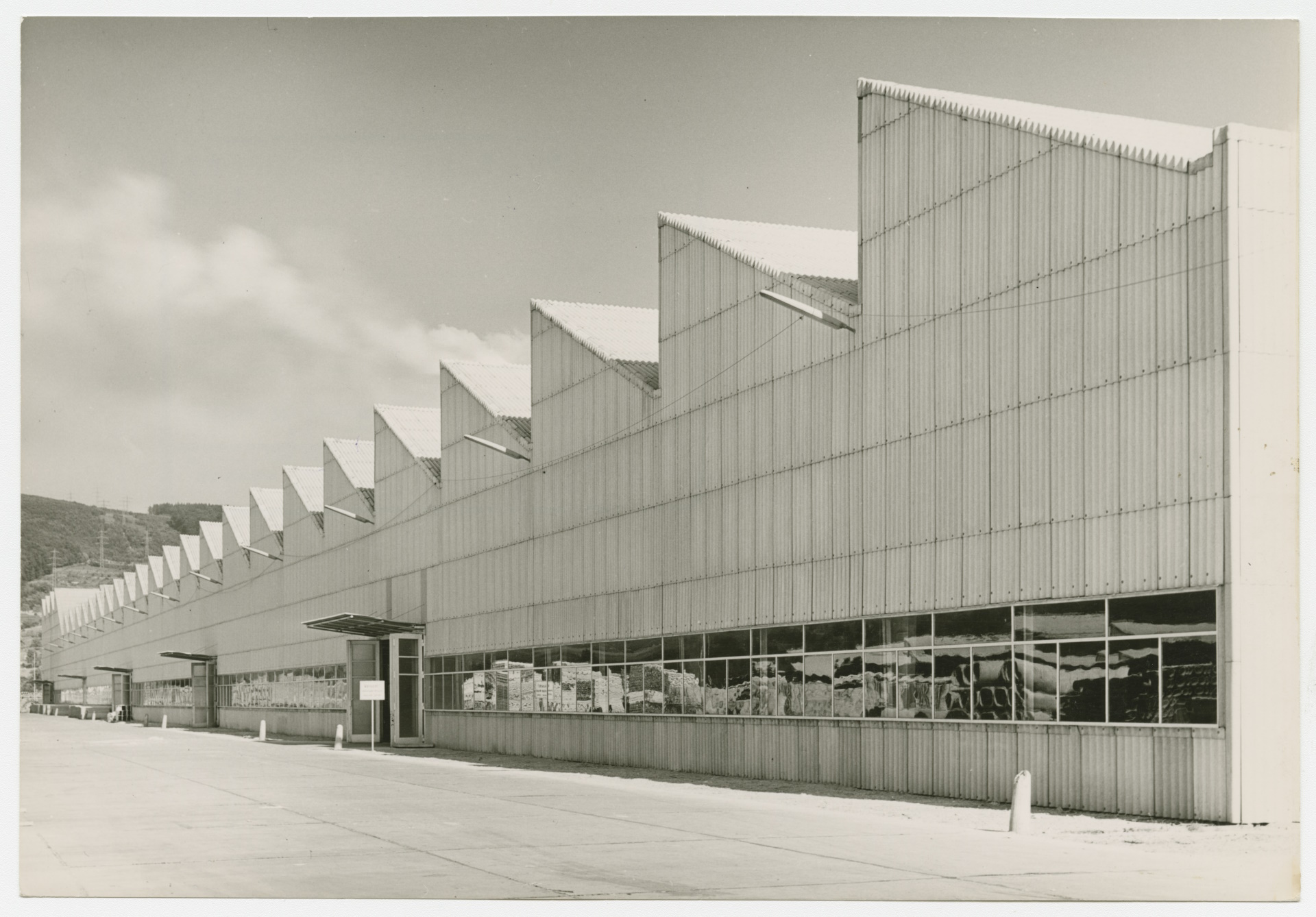
In 1953/54, a second large plant was constructed: the Eternit plant. It was located in the immediate vicinity of the cement plant Leimen. The plant with its characteristic halls was designed by the architect Ernst Neufert. Over 4,000 people worked at the Eternit plant in the 1970ies. Today, the Eternit plant is owned by Etex Group. The production of corrugated cardboard, roof tiles and molded parts was discontinued, while the paints plant’s production site was increased to 3.5 ha.
In the mid 1960ies, the commercial area Rohrbach Süd, located on Heidelberg municipality land to the north of the Eternit plant, was developed. In this context, the federal road (Bundesstraße 3), located to the west, was reconstructed. Development works included installing the railroad tracks leading to Heidelberg Materials. Two extensions to the railroad tracks connected the Eternit site to local trains running there until the track was abandoned in 2014. From the 1970ies onwards, several companies started settling in the commercial area Rohrbach Süd until the area was in full use by the mid 1990ies.
In 1992, development of that part of the commercial area that was located on Leimen municipality land begun based on the zoning map “Gewerbegebiet Nord Teil II” (Commercial Area North Part II). The zoning map not only determined the creation of commercial sites but also the construction of the road Stralsunder Ring, which was set to connect Rohrbacher Straße and Schwetzinger Straße. By the mid 1990ies, the zoning maps for the western areas close to Peter-Schuhmacher-Straße and Travemünder-Straße came into force. With the exception of the south-eastern part in the area surrounding the open-field system Fautenbühl, neighboring commercial sites have been connected to the utility system. The large plant sites of Heidelberg Materials and Etex are located right in the middle of the Special-Purpose District territory. So far, due to their location, they have not been developed sufficiently to allow for wasteland to be activated for high quality industrial-commercial re-use.
This will be one of the main tasks for the Special-Purpose District in the coming years. Urban planning will also take into account the special historic legacy and integrate it into the new identity of this site.